تجزیه و تحلیل وضعیت جوی در سال زراعی 93-94 /فصل اول( مهر- آبان-آذر)

وضعیت
موضوع بسته شده است.

Amir Mohsen

متخصص بخش هواشناسی
تا 126 ساعت آینده اپدیت شده.با توجه به وضعیت امروز مشهد بارش خیلی خوبی رو بنظر من دشت خواهد کرد. نگران نباشید اصلا


Amir Mohsen

متخصص بخش هواشناسی
مثلا جی ف اس که واسه مشهد 9 میلیمتر پیش بینی کرده ضربدر 3 کنید و حدود 25 تا 27 میلیمتر بصورت تجمعی بارش خواهیم داشت.
 

Amir Mohsen

متخصص بخش هواشناسی
مدل منطبق بر توپوگرافی جی اف اس وضعیت بارش امروز رو اینطوری پیش بینی کرده:


Amir Mohsen

متخصص بخش هواشناسی
در این مدل برای بعد از ظهر دوشنبه وزش شدید باد از مست همدان و مرکزی به سمت دامنه های غربی البرز قابل مشاهده است اگه وزش باد از مسیر بدون بارشی در طی روزهای گذشته عبور کنه قطعا گرد و غباری غلیظی رو به دنبال خواهد داشت.
مطلب دیگه اینکه در اون نواحی که سرعت وزش باد بالاست احتمال کولاک برف در صورت بارندگی بسیار زیاده:

 
سلام دوستان...ای سی ام چرا مسخره بازی در اورده... کانادا و نیروی دریایی عالی بودن نمیدونم چرا همیشه یه مدل باید بر خلاف جربان آب شنا کنه...
 

Amir Mohsen

متخصص بخش هواشناسی
مشهد:

Thursday 11/06 80%
Snow will taper off and end during the morning but skies will remain cloudy during the afternoon. High 3C. Winds SE at 10 to 15 km/h. Chance of snow 80%. 3-7cm of snow expected.
Thursday 11/06 20%
A few clouds from time to time. Low -2C. Winds light and variable.

TimeTemp.Feels LikeDew PointHumidityConditionsPrecip.Hourly Precip.WindCloud CoverPressure
12:00 am4 °C1 °C2 °C87%Snow71%1 mm11 km/h SE96%1022hPa
1:00 am3 °C0 °C2 °C93%Snow78%1 mm14 km/h SE96%1022hPa
2:00 am3 °C-1 °C2 °C94%Snow78%1 mm13 km/h SE97%1022hPa
3:00 am3 °C-1 °C2 °C95%Snow78%1 mm14 km/h SE97%1023hPa
4:00 am2 °C-1 °C2 °C98%Snow84%1 mm11 km/h SE97%1023hPa
5:00 am2 °C-2 °C2 °C100%Snow84%1 mm13 km/h SE97%1024hPa
6:00 am2 °C-2 °C2 °C100%Snow84%1 mm13 km/h SE98%1025hPa
7:00 am2 °C-2 °C2 °C99%Snow83%1 mm14 km/h SE98%1025hPa
8:00 am2 °C-2 °C2 °C98%Snow82%1 mm13 km/h SE97%1026hPa
9:00 am2 °C-3 °C1 °C96%Snow82%1 mm16 km/h SE97%1026hPa
10:00 am2 °C-2 °C1 °C94%Snow Showers64%0 mm13 km/h SE97%1026hPa
11:00 am2 °C-1 °C1 °C92%Snow Showers62%0 mm11 km/h SE96%1026hPa
12:00 pm2 °C-1 °C1 °C89%Snow Showers60%0 mm11 km/h SE95%1025hPa
 

Amir Mohsen

متخصص بخش هواشناسی
ساعت 10:30 امروز


The Jet Stream


Introductory Comments

Late in World War II high flying bombers on missions over Japan and Germany ran into very strong head winds. These winds were often in excess of 200 miles an hour and planes occasionally found themselves stationary over their target area. These encounters were the first observations of the jet stream. Considerable work during the late 1940s and 1950s expanded our knowledge of the jet stream both theoretically and observationally. The purpose of this web page is to explore some of this discoveries and outline aspects of the jet stream that are important to operational forecasters.

Jet Stream Definitions

The term "jet stream" can be used to refer to any concentrated area of high wind speed. In practice, however, the term is typically limited to the high speed winds in the upper troposphere. The terminology below combines definitions from the World Meteorological Organization (WMO) and American Meteorological Society (AMS) into the descriptions used for this web page.

Jet Stream

A ribbon-like current of high speed air typically found in the upper troposphere and characterized by strong vertical and horizontal wind shears. The minimum wind speed used to analyze the location of the jet stream is 50 knot. Jet Stream Axis

A line of maximum wind speed found at one pressure level. Jet Stream Core

Used in two ways:
  1. The area along the jet stream axis with the greatest wind speed.
  2. The line of maximum wind speed found in both the vertical and horizontal directions. The jet stream axis is a reflection of the jet stream core at one pressure level.
Jet Streak

This is an area of maximum wind speed along the jet stream axis denoted by a closed isotach. This is a variation on the (a) definition of a jet stream core. Jetlet

This is a small, relatively weak jet streak.


برای اطلاع از جزئیات بیشتر بر روی لینک زیر کلیک کنید

http://www.wxonline.info/topics/jetstream.html
​
 

Amir Mohsen

متخصص بخش هواشناسی
JET STREAK WIND AND JET STREAK MOVEMENT


METEOROLOGIST JEFF HABY
The jet stream is a fragmented global wind flow that encircles the mid-latitudes in a wavelike pattern. Embedded within this global wind belt are jet streaks. A jet streak is a segment of the jet stream that has relatively high velocity winds. Other terms for a jet streak are a jet max and a jet surge. Jet streaks are caused by a large low-level temperature gradient, thus they are more intense in the cool season when the differential in temperature between the polar regions and tropical regions is largest. Jet streaks are analyzed near the 300-mb level. Find jet streaks on the UNISYS 300 mb panel below:

http://weather.unisys.com/nam/300.php

It is a common error for beginning weather analysts to assume that the "entire" jet streak is moving at 160 knots. Think of a jet streak as an analogy to that of a thunderstorm. The thunderstorm moves at a certain speed (say 20 knots) while the winds within the updraft and downdraft of the thunderstorm move at a much faster speed (say 60 knots). The same is true for a jet streak. The jet streak itself may be moving at 25 knots while the winds moving through the core of the jet streak move at 160 knots. The wind accelerates as the air approaches the jet core and decelerates once leaving it.

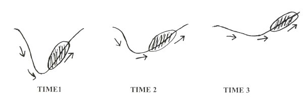
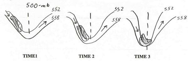
A jet streak moves within the trough-ridge pattern at the same time it influences the amplification or de-amplification of the trough-ridge pattern. The example below is that of a jet streak de-amplifying a trough. A strong jet streak on the right side of a trough will cause that trough to de-amplify (lift).

31a.jpg


If a strong jet streak is on the left side of a trough, the trough will amplify (dig) as shown below.

29a.jpg

​
 

golil

کاربر ويژه
شرایط اینجا کاملا در حال تغییر است بطوری که ابرهای سیاهی با ارتفاع پائین از سمت کوهها به سمت غرب در حال حرکت است
 

Amir-Hossein

کاربر ويژه
خیلی جالبه وضعیت

اون ابر سیاه داخل رنگین کمان در عکس بالا حالت ترنادو داره!
در عکس زیر که زوم کردم یه بخشی از برف دامنه های پایینی بینالود که از بیرونه دیده میشه


اینهم یک رنگین کمان دو قلوی دیگه در شمال غرب مشهد

رنگین کمان نه تنها در غرب مشهد بلکه در مرکز شهر هم دیده شد.
هوایی کـــــامــلا بـــــهـــاری

Sent from my WT19i using Tapatalk
 
وضعیت
موضوع بسته شده است.
بالا