-
توجه: در صورتی که از کاربران قدیمی ایران انجمن هستید و امکان ورود به سایت را ندارید، میتوانید با آیدی altin_admin@ در تلگرام تماس حاصل نمایید.
You are using an out of date browser. It may not display this or other websites correctly.
You should upgrade or use an alternative browser.
You should upgrade or use an alternative browser.
مباحث عمومی هواشناسی
- شروع کننده موضوع Amir Mohsen
- تاریخ شروع
- وضعیت
- موضوع بسته شده است.

Amir Mohsen
متخصص بخش هواشناسی
چلگرد کوهرنگ ۲ روز پیش

بسیار زیبا بود ، بهروز عزیز
به تاپیک اضافه شد:
http://forums.accuweather.com/index.php?s=&showtopic=31389&view=findpost&p=1818919
Amir Mohsen
متخصص بخش هواشناسی
Updated 01/17/2014 @ 11:00 UTC
Solar Update / Activity Increasing
Good morning. Attached is an updated image of the visible solar disk on Friday. Solar activity was technically low during the past 24 hours, although is picking up thanks to an approaching active region (or regions) located just behind the east limb. A number of C-Class flares were observed, including a C6.2 at 21:39 UTC Thursday evening, and C6.0 at 09:23 UTC early Friday morning. The activity looks to be the result of old regions 1936/1940 from the previous rotation. A bright coronal mass ejection (CME) became visible in STEREO Ahead COR2 imagery following the C6.2 event and was directed away from Earth. Based on the detected activity just behind the limb, there could be an increasing chance for a moderate M-Class event. Currently all visible sunspot regions remain quiet. Stay tuned to SolarHam.com for the latest updates.
Visible Solar Disk (Friday) - Click for Map
Amir Mohsen
متخصص بخش هواشناسی


Amir Mohsen
متخصص بخش هواشناسی


Amir Mohsen
متخصص بخش هواشناسی
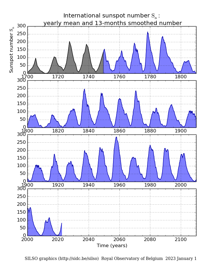
Yearly mean sunspot index over 3 centuries
Amir Mohsen
متخصص بخش هواشناسی


40 Years Ago, Iran Was Hit by the Deadliest Blizzard in History
Forty years ago this week, the deadliest blizzard on record ripped through the lower Caucasus and into
Iran, where it left 4,000 people dead. The Blizzard of 1972, as this hellish storm has come to be known, wasn’t your run of the mill squall; it wiped entire villages—200 villages, to be exact—off the map.
Coming on the heels of a series of storms in late January, the blizzard of 1972 traveled through western Iran and into Azerbaijan from about February 3 to February 8, dropping up to 26 feet of snow—that’s a two and half story building worth of snowfall—and snapping telephone lines, burying commuter trains, entombing villages, and crushing cars in its wake.
At the height of this blizzard, authorities estimated that a region about the size of Wisconsin, spanning most of western Iran, was entirely buried for more than a week. Those few who survived the -13 degree Fahrenheit temperatures were without water, food, heat and medical aid for days on end at a time when—just in case these poor people didn’t have enough to deal with—a deadly flu virus was also moving through rural Iran.
On February 9, 1972, after nearly a week of constant snowfall, the blizzard broke for a brief, but merciful, 24-hour period, allowing Iranian rescue workers to be transported by helicopter out to what looked essentially like enormous snow drifts—white expanses where villages used to be.
According to Associated Press reports, some rescue workers who’d been dropped on a snow drift burying a village called Sheklab dug for two days straight, burrowing through 8 feet of snow, only to find 18 frozen bodies and no one—not one single person in a population of 100—still alive.
Another blizzard started up again on February 11, forcing rescue workers to abandon their searches. Army helicopters left two tons of bread and dates scattered over the snowdrifts, in hopes that some people could tunnel their way to the surface, but many never did.
الان از پدرم در مورد این سال پرسیدم، اون سال خوزستان بودن و میگن بارشهای بسیار شدیدی در اون سال اتفاق افتاده تا حدی که سیل به راه افتاده.
جالبه که از کمینه پیشبینی شده هم کمتر هست!
به نظر میاد وضعیت الان خیلی شبیه سالهای اولیه قرن قبلی هست یعنی سالهای 1900.
Amir Mohsen
متخصص بخش هواشناسی
اسم اون سایتی که آرشیو بارندگی همه شهرها رو داشت چیه؟
http://www.chaharmahalmet.ir/iranarchive.asp
Amir Mohsen
متخصص بخش هواشناسی
Polar Vortex to Reinforce Extremes: Frigid East, Dry West
 By Alex Sosnowski, Expert Senior Meteorologist
January 17, 2014; 7:24 AM
More Sharing ServicesShare | Share on facebook Share on twitter Share on linkedin
 Weather expert Bernie Rayno discusses the setup for the bitter cold in this video.
The polar vortex will get stronger and move farther south later in January, causing cold to intensify in the Midwest and East and drought to build in California and the West.
As the pattern responsible for rounds of nuisance snow and waves of cold air continues into next week, indications are that bitterly cold air will return later in the month courtesy of the polar vortex.
There is the chance the cold may rival that of early January in some areas.
Impact from the new surge of very cold air may include the already familiar risks from below-zero temperatures including life-threatening conditions and frostbite. The cold may be intense enough to cause school closings, frozen pipes and water main breaks. Heating systems may struggle to keep up, people will spend more money keeping their homes and businesses warm and ice will again build up on area rivers. Where the cold is accompanied by snow, travel delays are likely.
RELATED:
AccuWeather.com Temperature Forecast Maps
AccuWeather Channel Coming in 2014
Will It Snow on February 2 at East Rutherford, N.J.?
A piece of the polar vortex will continue to hover around Hudson Bay and northern Quebec, Canada, into next week.

In this position, the vortex will continue to act like a giant pinwheel producing a series of weak storms with spotty snow and flurries, as well as brief waves of moderately cold air over southern Canada and the North Central and Eastern United States.
However, during the third and fourth weeks of January, some changes will take place. The high amplitude pattern is forecast to get more extreme. The polar vortex will move farther south and get stronger. The pattern will gradually change the current mixture of Pacific and Arctic air in the Canada Prairies and the North Central U.S. to all Arctic air. The air will get significantly colder over the Canada Prairies and the much of the eastern half of the nation as a result.

West Impact
Storms from the Pacific Ocean will be blocked from rolling onshore along the West coast.
Warmth in much of the West now will continue, with virtually no chance of rain and probably no snow for the Sierra Nevada in California. Above-average warmth in Alaska will likely get more extreme.
Air stagnation and fog may become more of a problem in parts of the West. The risk of wildfires will continue and may get worse. The drought will worsen.
East Impact
The pattern has the potential to produce days of near- to below-zero cold from the northern Plains to parts of the Midwest, more lasting cold in the Northeast and noteworthy episodes of cold over the interior South.
Since the path of the bitterly cold air will be first directed over the North Central states, the cold will not be quite as severe by the time it reaches the Northeast, similar to that of early January.
Prior to and during the main push of the coldest air later in the month in the East, there may be a large storm or two.
According to Senior Meteorologist Bernie Rayno, "We could have a storm slice out of the South Central states and into the mid-Atlantic and Northeast that puts down snow."
Any deep snow cover that occurs could make the cold more severe. Deep snow acts as an insulator to the warming effects of the ground.
"If there is no big snow ahead of the cold in the East, it may take more of the extreme out of the cold," Senior Meteorologist Henry Margusity explained.
The new invasion of frigid air will produce lake-effect snow downwind of areas of open water. While much of Lake Erie has frozen over, most of the other Great Lakes are still open. Some areas immediately downwind of Lake Erie may get colder with this outbreak, compared to the last as a result.
If it is any comfort, during the frigid weather forecast, the daylight will be a bit longer, when compared to just past New Year's Day. However, the few extra minutes of daylight will have minimal effect on the air mass that could rival the early January visit from the polar vortex.
January 17, 2014; 7:24 AM
More Sharing ServicesShare | Share on facebook Share on twitter Share on linkedin
The polar vortex will get stronger and move farther south later in January, causing cold to intensify in the Midwest and East and drought to build in California and the West.
As the pattern responsible for rounds of nuisance snow and waves of cold air continues into next week, indications are that bitterly cold air will return later in the month courtesy of the polar vortex.
There is the chance the cold may rival that of early January in some areas.
Impact from the new surge of very cold air may include the already familiar risks from below-zero temperatures including life-threatening conditions and frostbite. The cold may be intense enough to cause school closings, frozen pipes and water main breaks. Heating systems may struggle to keep up, people will spend more money keeping their homes and businesses warm and ice will again build up on area rivers. Where the cold is accompanied by snow, travel delays are likely.
RELATED:
AccuWeather.com Temperature Forecast Maps
AccuWeather Channel Coming in 2014
Will It Snow on February 2 at East Rutherford, N.J.?
A piece of the polar vortex will continue to hover around Hudson Bay and northern Quebec, Canada, into next week.
In this position, the vortex will continue to act like a giant pinwheel producing a series of weak storms with spotty snow and flurries, as well as brief waves of moderately cold air over southern Canada and the North Central and Eastern United States.
However, during the third and fourth weeks of January, some changes will take place. The high amplitude pattern is forecast to get more extreme. The polar vortex will move farther south and get stronger. The pattern will gradually change the current mixture of Pacific and Arctic air in the Canada Prairies and the North Central U.S. to all Arctic air. The air will get significantly colder over the Canada Prairies and the much of the eastern half of the nation as a result.
West Impact
Storms from the Pacific Ocean will be blocked from rolling onshore along the West coast.
Warmth in much of the West now will continue, with virtually no chance of rain and probably no snow for the Sierra Nevada in California. Above-average warmth in Alaska will likely get more extreme.
Air stagnation and fog may become more of a problem in parts of the West. The risk of wildfires will continue and may get worse. The drought will worsen.
East Impact
The pattern has the potential to produce days of near- to below-zero cold from the northern Plains to parts of the Midwest, more lasting cold in the Northeast and noteworthy episodes of cold over the interior South.
Since the path of the bitterly cold air will be first directed over the North Central states, the cold will not be quite as severe by the time it reaches the Northeast, similar to that of early January.
Prior to and during the main push of the coldest air later in the month in the East, there may be a large storm or two.
According to Senior Meteorologist Bernie Rayno, "We could have a storm slice out of the South Central states and into the mid-Atlantic and Northeast that puts down snow."
Any deep snow cover that occurs could make the cold more severe. Deep snow acts as an insulator to the warming effects of the ground.
"If there is no big snow ahead of the cold in the East, it may take more of the extreme out of the cold," Senior Meteorologist Henry Margusity explained.
The new invasion of frigid air will produce lake-effect snow downwind of areas of open water. While much of Lake Erie has frozen over, most of the other Great Lakes are still open. Some areas immediately downwind of Lake Erie may get colder with this outbreak, compared to the last as a result.
If it is any comfort, during the frigid weather forecast, the daylight will be a bit longer, when compared to just past New Year's Day. However, the few extra minutes of daylight will have minimal effect on the air mass that could rival the early January visit from the polar vortex.
Amir Mohsen
متخصص بخش هواشناسی

Amir Mohsen
متخصص بخش هواشناسی
به غیر از این یه سایتی بود که خارجی بود اونو نمیدونید اسمش چیه؟
free meteo
free meteo
خیلی خوبه که در سایت های خارجی فعالیت می کنی . چون اکثر خارجی ها فکر می کنن ایران همش صحرا و بیابان هست . با این کار ایزان رو می شناسن .
Amir Mohsen
متخصص بخش هواشناسی
خیلی خوبه که در سایت های خارجی فعالیت می کنی . چون اکثر خارجی ها فکر می کنن ایران همش صحرا و بیابان هست . با این کار ایزان رو می شناسن .
خواهش میکنم آبتین جان
من هم فعالیت شما رو در هر دو انجمن خیلی می پسندم. مفید و بدون حاشیه:گل:
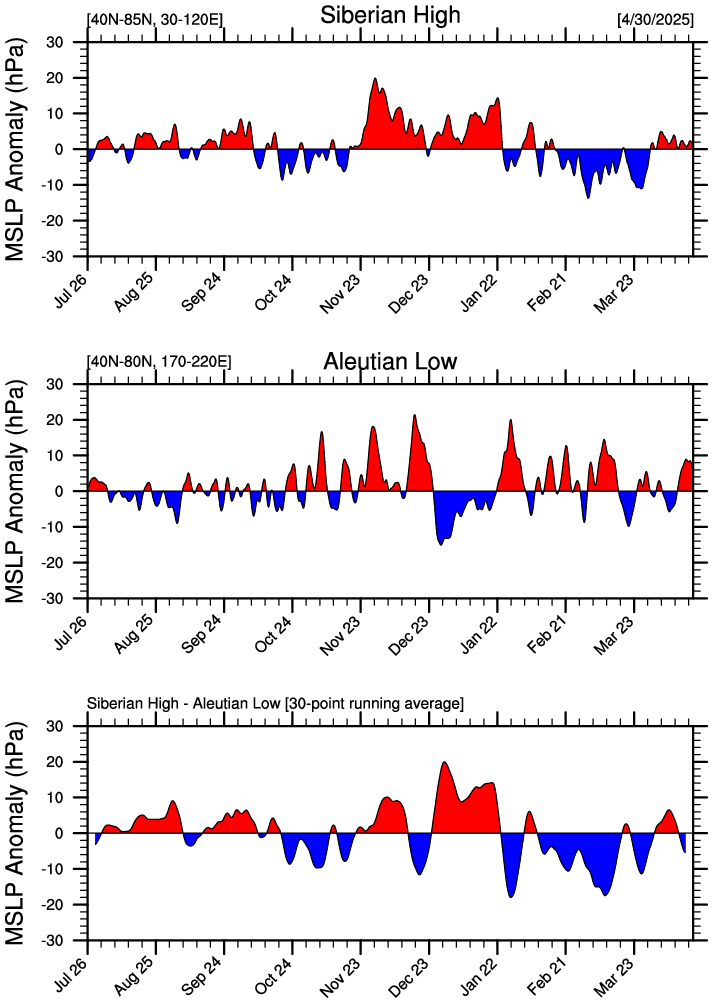
پرفشار سیبری همچنان پر قدرت!
خواهش میکنم آبتین جان
من هم فعالیت شما رو در هر انجمن خیلی می پسندم. مفید و بدون حاشیه:گل:
پرفشار سیبری همچنان پر قدرت!
دوست دارم اطلاعاتم درباره هواشناسی زیاد بشه ولی در این دو ساله در گیر پایان نامه ارشد هستم . همش در حال جمع اوری اطلاعات و مقاله درباره رشته خودم هستم .
- وضعیت
- موضوع بسته شده است.